Posted on

The particularities of the migratory movement in Venezuela, the Guianas and Suriname

  • Migration in the Colombian Amazon was not a state project but a consequence of the army’s armed conflict with the FARC and the emergence of drug trafficking that grew in its shadow.
  • Although the peace process began in 2017, changes that have occurred since then have given rise to new criminal groups after the guerrillas were eradicated.
  • Although the Guiana Shield has escaped large-scale deforestation, the region is home to tens of thousands of wildcat gold miners exploiting mineral resources in the thinly populated hinterlands of Venezuela, Guyana, Suriname and French Guiana.

The modern history of internal migration in Colombia began in a manner that was not unlike the processes organized by the governments in Brazil and the other Andean countries in the 1960s and early 1970s. However, that process was derailed first by a civil war and subsequently by the production of illicit drugs, largely because of tactics pursued by the Fuerzas Armada Revolucionarias de Colombia (FARC). The conflict effectively suppressed state infrastructure investment while freezing land acquisition by middle-class families and investors. At the same time, however, it fuelled the migration of displaced peasants, who opted to cultivate coca under the protective umbrella of the FARC.

The conflict officially ended in 2017 via the so-called Peace Process, which brought momentous change to the Colombian Amazon. The FARC no longer exists as an organized military entity, but it has been replaced by criminal groups composed of demobilized guerillas and militia members. Unfortunately, the state has not established a meaningful presence in the region and the cessation of hostilities has triggered a land rush supercharged by the drug trade and the cattle industry.

Two young people ride a motorbike on the street that divides Tabatinga in Brazil from Leticia in Colombia. Crime rates have risen sharply in the region. Image by Ivan Brehaut.

Migratory pathways

Before the civil war, the administration of President Carlos Lleras Restrepo (1966–1970) created the Instituto Nacional de Colonización (INCOR) in an attempt to respond to the demand for land by the rural poor. The strategy was supported by multiple grants from The World Bank, including The Caquetá Land Colonization Project, which sought to expand, organize and support the spontaneous colonization process of settlers moving from Huila in the previous two decades. Unfortunately, these were not particularly successful, although the government support consolidated the now-predominant cattle production model.

Caquetá was both a source and a sink of refugees in the 1980s, as people moved within the country to escape violence. During the 1990s and 2000s, the department was a net source of migrants, as an estimated 100,000 people were forced to vacate approximately 450,000 hectares (1.11 million acres) of land. Many moved to Bogotá. As of 2020, the department of Caquetá had a population of about 300,000 inhabitants, 99 per cent of whom were descendants of immigrants who had moved to the region in the last fifty years.

A similar history explains the settlement of the Colombian Putumayo, which occurred originally in conjunction with the advent of oil exploration and was fed by the movement of individuals from the adjacent Andean highlands. Although cattle ranching occupies the largest area, deforestation was largely driven by coca cultivation during most of the 1990s and 2000s. As in Caquetá, ranchers consolidated smaller landholdings that were originally created by coca farmers.

A section of cleared forest in the Colombian Andean Amazon, in the department of Putumayo. Image by Natalia Pedraza.

Migration into Meta and Guaviare in the 1990s and 2000s was almost entirely linked to the production of coca leaf and efforts by the FARC and other militias to extend their influence over the landscapes at the edge of the agricultural frontier. Successive waves of peasant settlers have occupied the landscapes surrounding Parque Nacional Natural Sierra de la Macarena, which the FARC has used as a staging area and refuge since the 1960s.

Their operational tactics changed in the 1980s, when they embraced the illicit drug trade as a source of revenue and actively protected peasant farmers growing coca leaf. Roads did not exist in the forest frontier, nor was it advantageous for coca growers to colonize landscapes accessible by vehicular transport. Consequently, the coca growers and the influence of the FARC expanded by using forest trails and river networks.

The peace process has radically changed this dynamic. Land speculators are financing the relocation of small farmers, who are encouraged to ‘move on’ as their original holdings are consolidated into cattle farms that are now accruing value as the region opens to investment. The central government hopes to limit development in the buffer zones around both Macarena and Chiribiquete national parks, and has limited its infrastructure investment to a limited number of major arteries; however, the local officials and land speculators have been building secondary and tertiary roads at an alarming rate.
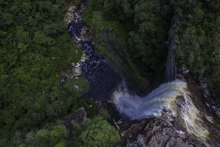
Chiribiquete supplies 60% of the surface water in the entire Colombian Amazon. Image courtesy of the National Natural Parks System of Colombia.

Venezuela and the Guianas

Successive Venezuelan governments have viewed the natural resources of the Guiana Shield as an economic asset that should be used for national development. This strategy was formulated in the mid-twentieth century and led to the creation of a state-owned enterprise, the Corporacion Venezolana de Guayana (CVG), to develop mineral and hydrological resources. This decentralized, state-owned conglomerate was established in the 1960s and created a variety of subsidiaries dedicated to the mining and processing of iron ore and steel, bauxite and aluminum, and the development of coal and hydropower energy. The state’s presence was further consolidated in the early 1970s, when President Rafael Caldera (1969–1974, 1994–1999) built a modern highway through the southeastern Gran Sabana region to connect with BR-174, which linked Venezuela with the Brazilian Amazon.

Originally, most of the CVG subsidiaries were efficient producers and competed successfully in international mineral markets; however, their viability as business enterprises declined as their mines aged, industrial assets depreciated and national competitiveness eroded because of mismanagement. The administrations of President Hugo Chávez (1999–2013) and his successor, President Nicolás Maduro (2013–present) bankrupted most of these state-owned business enterprises. Nevertheless, migration into the region has continued because of the allure of the ongoing gold rush, facilitated by the military authorities who now oversee development in the southeastern state of Bolívar.

Guyana and Suriname are coastal countries with historical and cultural ties to the island nations of the Caribbean. Economically they are very dependent on their mineral resources, and they apparently view their Amazonian territories as a natural resource to be exploited when opportunities present. Neither country has designated large areas for protection, and their indigenous territorial systems are relatively small. Most land is held in an unallocated forest reserve. The government of Guyana recently has sought to develop an international transport corridor that would link the emerging agricultural landscapes in Roraima, Brazil, with port facilities in Georgetown. This could change the land-use dynamic along that road as settlers create outposts to provide key services to the transport sector.

The borders among Guyana, Suriname and French Guiana have been managed diplomatically among the colonial powers and the independent states that succeeded them. None of these states seems genuinely interested in colonizing their interior provinces. The border between Venezuela and Guyana is the only remaining contested terrestrial border in the Western Hemisphere. The long-simmering dispute over Guyana’s mineral-rich Essequibo region, which never led to armed conflict, flared up again following the 2015 discovery of an offshore oil deposit potentially worth hundreds of billions of dollars.

The floodplains of the Andean piedmont and certain geologically defined landscapes on the Brazilian and Guiana Shield attract tens of thousands of wildcat miners, who employ placer mining technology that is particularly destructive and extraordinarily toxic. Credit: IBAMA & Vincius Mendonça, CC BY-SA 2.0, Flickr.com Ryan M. Bolton, Shutterstock.

Migratory pathways

The Guiana Shield has escaped the large-scale settlement and deforestation that characterize both Amazonian Brazil and Andean countries. This does not mean, however, that it has not been impacted by migration. The region is home to tens of thousands of wildcat gold miners exploiting mineral resources in the thinly populated hinterlands of Venezuela, Guyana, Suriname and French Guiana. These miners are a combination of local inhabitants and fortune-seeking immigrants, mainly Brazilian, whose numbers fluctuate in response to changes in the price of gold. The Suriname government estimates the country has about 20,000 small-scale mining operations, each of which probably employs between five and ten individuals. Most mine owners are native-born Maroons who employ thousands of Brazilian garimpeiros.

It is difficult to know precisely what is transpiring in Venezuela because of the chaotic governance that has characterized the country for the last decade. According to 2011 national census, the municipality of Sifontes had a population of 51,000, but recent reports suggest that this number may have surged to more than 400,000 by 2016. The gold mining region is controlled by the military, which operate numerous mines via joint ventures with Venezuelan businesspeople.

Many of these immigrants may not be gold miners, however, but individuals importing scarce goods from Brazil or seeking to emigrate. At the end of 2022, approximately 70,000 Venezuelans were living in Roraima and Amazonas, with some 33,000 in makeshift shelters and camps. Most, if not all, survive by working in the informal economy.

Banner image: A canoe of Indigenous design in Colombia. Image by J.J. Javier via Nia Tero.

“A Perfect Storm in the Amazon” is a book by Timothy Killeen and contains the author’s viewpoints and analysis. The second edition was published by The White Horse in 2021, under the terms of a Creative Commons license (CC BY 4.0).

To read earlier chapters of the book, find Chapter One here, Chapter Two here, Chapter Three here, Chapter Four here and Chapter Five here.

Chapter 6. Culture and demographic defines the present

Posted on

The fuel that moves people: the Ecuadorian case

  • In Ecuador, the main areas of colonization were a north-south corridor along the base of the Andes and the Sucumbíos-Orellana quadrant, the country’s major oil-producing region.
  • Since the 1970s, populations in both areas have grown significantly. The Andean zone went from 160,000 inhabitants to more than 520,000 in 2017; in parallel, the population in the provinces of Sucumbíos and Orellana increased from less than 12,000 to more than 350,000.
  • Colonization also led to the invasion of lands of the indigenous Shuar, which prompted an unusual effort on their part to protect their territory. Today, the area specializes in cattle production and seeks to establish a niche market for high-quality beef for the domestic market.

Throughout most of the twentieth century, the Ecuadorian authorities pursued a geopolitical strategy that reflected a long-held conviction that they were cheated out of large territories in the Western Amazon. Most of their claims were adjudicated in favor of Peru and they were on the losing side of border disputes in 1860, 1903 and 1941. Consequently, successive governments were intent on not losing another square meter of what they fervently believed was their national territory, a policy that led to the construction of several highways and deliberate policies to foster migration into their lowland provinces.

Peru and Ecuador resolved their differences in 1998, after another border dispute, via an arbitration process coordinated by the governments of Brazil, Argentina, Chile and the United States. In the process, the countries established paired national parks on both sides of the border, and an ambitious IIRSA-sponsored initiative was launched to provide Ecuador with direct access to the Amazon waterway at Puerto Morona. The resolution of the border conflict and the much-improved transportation infrastructure opened up the Cordillera del Condor to large-scale mining operations operated by Canadian and Chinese corporations.

The road network in Amazonian Ecuador closely corresponds to the petroleum pipeline system, partly because the government promoted settlement along service roads during the 1970s. Data sources: GEM (2023) and RAISG (2022).

Migratory pathways

Migration into Amazonian Ecuador has occurred via four highway routes that connect urban centers in the Andes with a town or small city in the lowlands; from north to south, they include Quito to Nueva Loja (E10), Ambato to Puyo (E30), Cuenca to Macas (E40) and Loja to Zamora (E45). These roads channeled migrants into two major colonization landscapes: a north-south corridor along the base of the Andes, and the Sucumbíos-Orellana quadrant, which is also the country’s primary oil-producing region. The population along the piedmont grew from about 160,000 inhabitants in 1970 to more than 520,000 by 2017; simultaneously, the inhabitants of the Sucumbíos and Orellana provinces increased from fewer than 12,000 to more than 350,000.

Most communication was up and down mountain valleys between individual highland and lowland population centers, but eventually these communities were linked by a rudimentary north-south highway (Route 45). Multiple roads extended east into the Amazon lowlands, including one along the border to Tiwinza, a military post on the Santiago River, and an alternative route from the north to connect with Puerto Morona on the Morona River.

This latter route caused significant encroachment by Colonos on traditional lands of the Shuar Indigenous people in the 1970s and led to an unusual effort on their part to protect their land. This occurred two decades before Indigenous organizations launched their campaign to promote communal tenure regimes, and Shuar families had no option but to apply for legal title using the administrative procedures of the national colonization agency. This obligated them to deforest small plots within the larger landscapes of their traditional territories.

In 1997, the government allocated funds to improve infrastructure, with the modernization of Route 45, now known as the Troncal Amazónica. Settlement along the highway and into the Amazonian lowlands occurred mainly in the 1970s via development initiatives organized by a regional development entity (CREA) with financing from the IDB. The area now specializes in cattle production and seeks to establish a niche market for high-quality beef for the national market.

A researcher sets up a camera trap in Yasuní National Park in the Ecuadorian Amazon. Image by Jeremy Hance & Tiffany Roufs.

Migration into the southern sector was supported by a regional development organization, but most immigrants came on their own. They included Indigenous Quechua speakers, as well as Ecuadorians of mixed racial heritage, all of whom encroached upon the traditional lands of the Shuar. The super humid climate and rolling topography make intensive cultivation impossible, and the principal economic activity is raising beef and dairy cattle.

In contrast, colonization of the Sucumbíos-Orellano quadrant reflects a proactive settlement policy implemented by the central government after the completion of the highway between Quito and Lago Agrio in 1967. The military government declared Sucumbíos a ‘zone for migration and expansion’ in 1972 and sent teams of surveyors to lay out transects of fifty-hectare plots (250 meters by 2,000 meters) for distribution to new arrivals. The network of nearly identical landholdings was established along a rapidly expanding secondary road network, which was created to support the feeder pipelines that carry crude oil to pumping stations in Lago Agrio.

The soils in the quadrant are relatively fertile, which has allowed for the development of a diverse assemblage of productive systems, including food staples and cash crops such as coffee, cocoa and palm oil. Like other colonization schemes of the 1970s, poor infrastructure and inadequate public services led to widespread disenchantment, and many farmers abandoned their farms. Simultaneously, oil field workers filed claims to acquire plots or purchased abandoned farms from people seeking to leave the region. Many owners adopted a beef production strategy that allowed them to meet the legal requirements for a land claim, but which could be managed by an absentee owner. Consequently, the ethnic makeup of the quadrant is relatively diverse.

The government now seems dedicated to promoting the development of Amazonian Ecuador by embracing the intensification of agricultural production on previously deforested landscapes, while promoting a diversification of production strategies. The government continues to build new oil pipelines and access roads as it expands into new production fields in previously remote landscapes in and around Yasuní National Park. The government’s insistence on developing these assets is highly controversial and a source of conflict with Indigenous groups, particularly the Waorani, whose ancestral territory lies over Ecuador’s most valuable oil reserves.

“A Perfect Storm in the Amazon” is a book by Timothy Killeen and contains the author’s viewpoints and analysis. The second edition was published by The White Horse in 2021, under the terms of a Creative Commons license (CC BY 4.0).

To read earlier chapters of the book, find Chapter One here, Chapter Two here, Chapter Three here, Chapter Four here and Chapter Five here.

Chapter 6. Culture and demographic defines the present

Posted on

The rubber boom and its legacy in Brazil, Peru, Bolivia and Colombia

  • In the Amazon, the rubber boom was facilitated by new technological developments, industrialization and political change.
  • While in Brazil the rubber barons used a form of debt slavery with their workers, in Bolivia the rubber boom was dominated by pioneers from Santa Cruz who had established cattle ranches in the Beni during the nineteenth century.
  • In Peru, the boom was based on the exploitation of Castilla species rather than Hevea, resulting into a much more destructive process, which developed a particularly cruel and exploitive slave-labor system.

The invention of vulcanized rubber (1839), followed by the popularization of bicycles (1870s) and the invention of the automobile (1886), led to exponential growth in the demand for rubber, which was manufactured from latex produced by several species of trees endemic to the Amazon forest. The supply of rubber was a component of the trade in the drogas de sertão, which included latex collected from multiple species of two genera, Hevea and Castilla. The most valuable species were members of the genus Hevea, because their latex could be tapped rather than harvested from a felled tree, as was the case for Castilla. This difference soon led to the development of a Hevea supply chain anchored in remote outposts permanently manned by individuals who would collect the latex, process it into rubber using artisanal technologies and sell it to a trader for transport downriver to an export agency in Belem, Manaus or Iquitos.

At the outset, most rubber was collected by Indigenous communities residing in mission villages or Ribeirinhos who supplemented their subsistence livelihoods with trade in forest products. Strong annual growth in the demand for rubber quickly exceeded the ability of the resident population to provide a steady supply, however, stimulating the flow of migrants into the region.

During the last half of the nineteenth century, mass migration was facilitated by new technologies. Telegraph systems and newspapers alerted individuals to new opportunities, while trains and steamships would transport them across oceans and continents. Social mobility catalyzed by industrialization and democratic revolutions contributed to sudden migratory events symbolized by the gold rushes of California, the Yukon and South Africa. The Amazon became a global destination for adventurers seeking to strike it rich by joining a new global commodity boom.

The extent of the rubber economy was defined by the distribution of Hevea, where the latex was sustainably harvested by tapping over many years, and Castilla, where collectors sacrificed the tree to harvest a much larger, but one-time, crop of latex. Data source: Priyadarshan and Goncalves 2003.

Brazil

Most of these international migrants were poorly suited to the task, however, and the most successful rubber merchants were native-born entrepreneurs. These men were adept at leveraging local knowledge with political influence and the use of violence to dominate the wilderness landscapes they claimed as their fiefdoms. Known throughout the world as ‘rubber barons’, in Brazil they were called seringalistas. They were successful because they acquired monopoly control over a specific tributary, which allowed them to ruthlessly exploit their workers, who were known as seringueiros.

The seringalistas would advance the novice seringueiros supplies at inflated prices, establishing a debt so large that the worker could never fully repay it – a condition for his departure from a remote rubber post. Known as aviamento, this form of debt slavery was particularly effective for entrapping migrants who were not skilled at living off forest resources and who lacked a support system of Indigenous or Ribeirinha communities that might have offered them an escape route.

Among the most consequential of Brazilian rubber barons was João Gabriel de Carvalho e Melo, an explorer and entrepreneur who was among the first individuals to discover the rich stands of Hevea trees on the upper Purus River in the late 1850s. This occurred at the dawn of the rubber boom, and the demand for seringueiros had already surpassed the capacity of the Ribeirinha communities to provide the requisite labour. João Gabriel returned to his hometown of Uruburetama, Ceará, where he recruited a cadre of friends and relatives who would return with him in 1874 to establish a series of rubber posts on Acre and Purus rivers.

Their migration coincided with a series of calamitous events in Northeast Brazil, including the collapse of the international cotton market (1865–1870) and a multi-year drought (1877–1880) that destroyed the regional economy. Famine forced more than 200,000 Nordestinos, almost all Caboclos, to emigrate. Approximately half headed for the Amazon, where the seringalistas were ready to loan them money and locate them on remote forest tracts as contract employees. Approximately 30,000 Nordestinos moved into the upper reaches of the Purus and Juruá rivers.

The traditional method of collecting latex is a labour intensive process that consists of tapping trees to collect the liquid, which is congealed into pelotas de seringa using smoke and heat. These were transported to regional centres for export to global and national markets. Left: © Shutterstock; Right: © iStock.

This inflow of Brazilian citizens further consolidated Brazil’s hold on its Amazonian territories and set the stage for one final expansion of its dominion, despite the 1867 Treaty of Ayacucho, which had adjudicated the territory of Acre to Bolivia. Acre was a roadless forest wilderness, and Bolivia had yet to effectively occupy the territory, which was populated entirely by Indigenous tribes. The region could be easily accessed by river from Manaus, however. Once it became obvious that the region was a treasure trove of natural rubber, the Bolivian government moved to occupy the province and enlisted influential foreign investors to finance the region’s development. They acted too late.

Tens of thousands of Brazilians poured into Acre in the 1890s. Although Bolivian troops staged campaigns and counterattacks, they had to traverse dense forest landscapes from their military outposts on the Río Madre de Dios. Known in Brazil as the Revolução do Acre, it was fought by an army of immigrant filibusters who created a short-lived independent republic (1899–1903). Although they acted autonomously, they enjoyed the support of authorities in Manaus, Belem and Rio de Janeiro. Brazil formally annexed the territory after the two countries signed the Treaty of Persépolis in 1903. By 1910, Acre had a population of approximately 50,000 and was producing about 60% of the rubber in the Brazilian Amazon.

Although Bolivia had little choice but to cede control of the province, the two countries negotiated a compensation agreement that included the construction of a railway that would circumvent the rapids on the Río Madeira. The new railroad, which would be built in what is now the Brazilian state of Rondônia, would provide Bolivia with an expedited commercial route for its Amazonian territories. This was the era of railroad investment mania, and investors in London and New York poured capital into the scheme, a formidable engineering undertaking because of the region’s remoteness and the threat of tropical diseases. A previous effort in the 1870s ended in litigation and bankruptcy. The Brazilian government made it a national priority, however, and it was built between 1907 and 1912.

The Estrada de Ferro Madeira-Mamoré (EFMM) was a massive project that employed between 2,000 to 3,000 men during the height of construction. It suffered enormous labour turnover, however, due to severe working conditions and endemic disease. By some estimates, as many as 30,000 men and women were employed over the life of the project, with a loss of life that exceeded 6,000 individuals. Many were foreigners who were ill-prepared for the tropical climate, but there was another infusion of Caboclos from Northeast Brazil. Ironically, the rail line was completed just as the Amazonian rubber industry collapsed because of competition from plantations in Malaysia.

The first national census of Brazil in 1872 enumerated 323,000 residents in the states of Pará, up from around 85,000 after the Cabanagem massacres. This was before the onset of the rubber boom (~1890), when the influx of Nordestinos surpassed 20,000 per year. Between 300,000 and 500,000 eventually would migrate into the basin, radically transforming the demographic profile of the Brazilian Amazon. By 1910, the non-Indigenous population in Pará, Amazonas and Acre exceeded 1.2 million, while estimates of Indigenous people had fallen to below 100,000.

The upper Rio Juruá was settled by seringueiros after about 1890; Cruzeiro do Sul was established in 1904 after Bolivia ceded Acre to Brazil in the Treaty of Persopolis. The town was connected to the Brazilian highway network in the late 1970s and has experienced steady growth due to the inflow of settlers who have established smallholdings in the surrounding upland landscapes. Source: Google Earth.

Bolivia

The Bolivian rubber boom was markedly different from its Brazilian counterpart because it was dominated by pioneers from Santa Cruz who had established cattle ranches in the Beni during the nineteenth century. These experienced frontiersmen were well positioned to occupy the forests along the Madre de Dios, Mamore and Iténez (Guaporé) rivers. The most successful of these entrepreneurs, Nicolás Suárez Callaú, established a trading post at Cachuela Esperanza near the junction of the Madre de Dios and Mamore rivers, where rapids obligated traders to portage their merchandise through his installations. Although nowhere near the size of Manaus or Iquitos, Cachuela Esperanza was the centre of the Bolivian rubber trade, with a radiotelegraph, cinema, state-of-the-art hospital, machine shops and, of course, warehouses to store rubber, which in Bolivia is called goma. Suárez also owned steamships, which he used to transport his merchandise and people both above and below the rapids that characterise this section of the Rio Madeira.

By 1912, the Casa Suárez controlled about 60% of Bolivian rubber production and had opened offices in London and other cities. Including his family’s cattle ranches in the Beni, the enterprise extended over 180,000 square kilometres. Suárez was also a patriotic Bolivian who financed a large portion of the country’s armed forces in the Acre War. Self-interest no doubt drove his determination to protect his monopoly, but, without his intervention, Bolivia probably would have lost most of the present day Department of Pando.

Most of the gomeros employed by the Casa Suárez were internal migrants from the lowland provinces of Bolivia, including Mestizos from the city of Santa Cruz, but also native Moxeños and Chiquitanos drafted from the mission villages established in the previous century. Nicolás Suárez and his brothers used a form of debt slavery similar to the Brazilian system, but the gomeros were part of a subservient patrón-peón system that prevailed in the rural landscapes of Chiquitania and Beni. Since they were part of an established serf-like system, they were also more likely to be accompanied by women, which undoubtedly contributed to their reputation for docility.

Less acculturated natives also were recruited, particularly the Tacana, who were skilled forest guides capable of locating populations of rubber trees. Unsurprisingly, the incursion of outsiders accelerated the decline of Indigenous peoples, especially the Araona, who were estimated to have a population of more than 20,000 in 1900, but today number fewer than a hundred. The Tacana have fared better, although their cultural legacy was changed through intermarriage with migrant workers from the south. Their descendants pursue subsistence livelihoods, but many live in the towns of Riberalta, Rurrenabaque and Guayaramerím. Some work as wildcat miners on dredges exploiting placer gold deposits along the Beni and Madre de Dios rivers.

The Estrada de Ferro Madeira-Mamoré (EFMM) was built between 1907 and 1912 as part of the compensation Bolivia received for ceding the Acre territory to Brazil. Courtesy of the Dana B. Merrill Collection, Museu Paulista (2011).

Peru and Colombia

The Jesuits and their successors were successful in keeping the Brazilian bandeirantes from encroaching into the Maynas province, but the onset of the rubber boom required more forceful action. In 1877, the Peruvian government sent three steamboats to establish a military base at Iquitos and reaffirmed that nation’s control over Maynas, whose territorial sovereignty was disputed by both Ecuador and Colombia. The village evolved into a small city and became a major centre for the trade of caucho, the Peruvian term for natural rubber. Like Manaus, Iquitos boasted opulent hotels and luxury items imported directly from Europe, which catered to Peru’s barones del caucho.

The production of caucho was based on the exploitation of Castilla species rather than Hevea; consequently, it was a much more destructive process, which developed a particularly cruel and exploitive slave-labor system. Because the whole tree was harvested, it produced a larger volume of rubber, which generated phenomenal revenue flows over the short term. The caucheros had no incentive to develop long-term rubber tapping stations. Rather, they sought out populations of Castilla that tended to occur in clumps of several hundred trees. Unsurprisingly, they would exterminate one local population and move on to the next.

The extractive nature of the system also influenced their need for labour. Instead of a docile peon who could be manipulated over years of drudgery, they relied on experienced woodsmen who could identify the Castilla groves and enslaved peons to fell trees and collect the latex. They would migrate with the former and conscript the latter from local Indigenous communities, typically by force, as they needed them. Historians have termed this terrorist slavery, because the caucheros were extraordinarily cruel and treated their peons as an expendable commodity that could be replaced as they expanded into new territories.

The most infamous of the Peruvian rubber barons was Julio César Arana del Águila, known as the Rey del Caucho because he organised a monopoly cartel extending from the Huallaga River to the Putumayo. Arana was ambitious, sophisticated and audacious, as exemplified by his decision to capitalise his enterprise on the London stock exchange as the ‘Peruvian Amazon Company’. Because travel to Iquitos from Lima could take weeks, Maynas was essentially an autonomous region, now known as Loreto, and the central government depended on Arana to project Peruvian sovereignty on frontier lands then disputed by Peru, Brazil, Colombia and Ecuador.

As in Brazil, the Ribereña population was unable to supply enough labour to meet the demand for rubber tappers. Arana initially imported labour from Brazil and the Caribbean, but soon elected to prey on the Indigenous nations of the Putumayo, particularly the Huitoto, Ocaina and Bora tribes, which were known for their peaceful (non-warlike) culture. His lieutenants were extraordinarily cruel and committed heinous crimes that today would be considered genocidal, including murder, kidnapping, rape, torture and enslavement. They were accused of exterminating entire villages during alcohol-driven bouts of sadistic entertainment.

The Indigenous people who avoided slavery suffered another round of disease and death. Here a Karipuna family near Porto Velho interacting with the photographer hired by the Estrada de Ferro Madeira- Mamoré. Reportedly, between 60 and 70 individuals survived into the current decade (Angelo 2023). Credit: Colecao Dana Merrill (2011).

Their actions were eventually revealed by an American who had travelled to the Amazon in search of wealth and adventure. Walter Hardenburg fell prey to the machinations of the Peruvian Amazon Company, but managed to escape and publish an exposé in a progressive London newspaper.

The resulting scandal motivated the British government to commission an enquiry under the direction of Roger Casement, a diplomat and civil rights advocate then serving as Consul General in Rio de Janeiro. His report, published in 1911, was corroborated by two Peruvian judges and a French journalist, which forced the House of Commons to investigate the atrocities. Julio César Arana testified in person and denied the allegations – or at least knowledge of the crimes. His employees avoided prosecution by disappearing, while Arana went on to represent Iquitos in the Peruvian Senate.

Like most rubber companies of the epoch, the Peruvian Amazon Company filed for bankruptcy in 1913, but during its two decades of operation it exported over 4,000 tons of rubber valued at about 1.5 million British pounds – an amount that, adjusted for inflation, would equal about US$ 300 million in 2022. Although the Peruvian Amazon experienced an inflow of migrants, the Indigenous inhabitants on the Putumayo were devastated, falling from about 50,000 in 1890 to only 6,000 in 1920, when Colombia and Peru enumerated the inhabitants as they demarcated the boundary between their countries.

The other major Rey del Caucho was Carlos Fermín Fitzcarrald López, the son of an Irish immigrant who exploited Castilla populations on the Ucayali and the Madre de Dios rivers. He is famous because he built a railroad across an eleven-kilometer isthmus separating the two watersheds. His goal was to create an export route from the Madre de Dios that avoided the interference of the Bolivians and Brazilians. He drowned at age 35, when one his steamboats capsized while trying to navigate rapids on the upper Urubamba River.

Fitzcarrald exploited Indigenous labor by deploying detribalized Indigenous crews in wilderness areas in the upper Ucayali and Madre de Dios watersheds, where he would entice uncontacted Indigenous groups into clearings and capture them for his slave-fueled enterprise. He enjoyed the collaboration of certain predatory Indigenous chiefs who would raid unsuspecting tribes; those that resisted were massacred. Fitzcarrald’s actions eventually led to the division of the Piro ethnic nation into two tribes: those who were coerced into servitude are now known as the Yine, while those who retreated into the wilderness are the Mashco.

Fitzcarrald’s death opened the Madre de Dios to a Spanish immigrant, Máximo Rodríguez Gonzales, who established a network that bordered, and blocked, the advance of the Bolivian rubber tappers employed by the Casa Suárez. Simultaneously, the Peruvians and Brazilians adjudicated their boundary areas on the upper Purus River, largely to Brazil’s benefit, because long stretches of the river had been occupied by seringueiros tapping the extensive Hevea groves that contributed to Acre’s preeminence in the Amazonian rubber industry.

Banner image: A clan of the so-called “Free Indians of the Ucayali River”, probably Shipibo-Conibo. Credit: Hardeman, 2012.

“A Perfect Storm in the Amazon” is a book by Timothy Killeen and contains the author’s viewpoints and analysis. The second edition was published by The White Horse in 2021, under the terms of a Creative Commons license (CC BY 4.0).

To read earlier chapters of the book, find Chapter One here, Chapter Two here, Chapter Three here, Chapter Four here and Chapter Five here.

Chapter 6. Culture and demographic defines the present

Posted on

Report reveals how environmental crime profits in the Amazon are laundered

  • A recent report from the FACT Coalition analyzed 230 cases of environmental crime in Amazon countries over the past decade to better understand how crimes are committed and how the associated profits are laundered.
  • It found that the U.S. is the most common foreign destination for the products and proceeds of environmental crimes committed in the Amazon region.
  • The most popular way to launder money involves the use of shell and front companies, and corruption was the single most prevalent convergent crime mentioned.
  • Of the cases analyzed, only one in three appears to have included a parallel financial investigation.

A new report by the FACT Coalition found that many investigations into environmental crimes do not follow the money. Of the 230 cases analyzed, 76% involved the use of front and shell companies, likely due to flaws in the anti-money laundering systems of foreign countries, researchers said. 

The environmental crimes analyzed occurred between 2014 and 2024 in Amazon countries, mainly in Colombia, Ecuador and Peru. The aim was to better understand how criminals operate and how the associated profits are laundered.  

The report pointed to weaknesses in the way the investigations were carried out — for instance, a lack of financial investigations — as well as the role of convergent crime, which played a role in most cases.  

“When it comes to environmental crimes that are committed in countries in the Amazon region, many cases are discovered accidentally,” Julia Yansura, the program director for environmental crime and illicit finance at the FACT Coalition and author of the report, told Mongabay over email. “A police officer happens to stop a vehicle or an airport security officer randomly checks a bag, and they find something. That approach is far from sufficient and often yields minor cases involving low-level criminals.” 

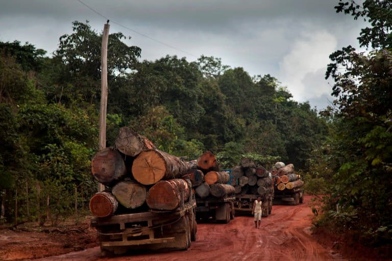
Trucks loaded with Amazon timber await the repair of a ferry used to cross the Curuá-Una river, close to Santarém, Pará State. Photo courtesy of Marizilda Cruppe for Greenpeace.
Trucks loaded with Amazon timber in Pará State. Image courtesy of Marizilda Cruppe for Greenpeace.

One in every three cases appeared to include a parallel financial investigation, the report said. Without financial investigations, it’s hard to find out who is responsible for these crimes and who is benefiting financially, Yansura explained. Criminal groups will most likely move to a different location and continue their crimes.  

“We see this frequently with illegal gold mining in South America,” she explained. “When authorities seize the gold and destroy the heavy machinery, criminal groups are back literally the next day, re-establishing operations a few miles away.”

A failure to conduct parallel financial investigations will likely only lead to the arrest and prosecution of low-level individuals who may be victims themselves, while those who are responsible remain free. Research by the World Wildlife Fund (WWF) has shown that as much as 40% of all deforestation worldwide is carried out by victims of modern slavery or forced labor.   

When it comes to the laundering of profits from environmental crimes, such as illegal logging, illegal mining and wildlife trafficking, the report found that the most common methods identified in the analysis involved front and shell companies, which are used to mask illegal activity.

Deforestation for agriculture in the Sepahua River watershed, Peru. Credit: © Jason Houston/Upper Amazon Conservancy.

According to the report’s findings, 25% of all cases, and 44% of “follow the money” cases, involved at least one foreign jurisdiction. The U.S. was the foreign jurisdiction mentioned most across all cases analyzed, either as a transit or destination point for illegally sourced natural resources, such as gold or timber, or dirty money.  

Robert Muggah, co-founder of the Brazilian-based think tank Igarapé Institute, told Mongabay this is because of “the abundance of shell companies, front companies and trade-based fraud that allow criminal actors to wash dirty money” in the country.

“To a large extent, U.S. businesses have not historically been required to identify their true beneficial owners to the Treasury Department,” he explained over email. “In the meantime, owing to uneven regulatory oversight and enforcement, U.S. banks have allowed large sums of cash to be transferred in the financial system by individuals involved in corruption, fraud and sanctions evasion.”  

Another reason why the U.S. is central to this network is because real estate is exempt from many rules related to countering money laundering, Muggah explained. “Networks of shell companies and foreign investors often purchase real estate to launder billions of dollars of profits generated by, among other things, environmental crime.” 

amazon landscape
Most of the environmental crimes analyzed by the FACT report occurred in Colombia, Ecuador and Peru. Image by Dimitri Selibas.

To address the issue, Yansura said the U.S. should implement the Corporate Transparency Act, which came into effect on Jan. 1, 2024, and is meant to increase transparency in business ownership and entity structures to combat laundering and other criminal activities. By ensuring this mechanism is up and running as soon as possible, “the U.S. could shut down one of the biggest loopholes currently being used by environmental criminals in the Amazon,” Yansura added.

Beyond the U.S., Muggah said national governments should follow the EU’s lead in ensuring that environmental crime is a predicate offense, a component of a more complex crime, often associated with money laundering or organized crime. In addition, anti-money laundering authorities can strengthen partnerships with environmental protection agencies, environmental crime investigators and other research organizations, “to assess the extent of vulnerabilities in financial and nonfinancial sectors to conceal and launder gains from environmental crime,” he said.  

Environmental crime was almost always accompanied by other converging crimes, such as corruption and drug trafficking, the FACT Coalition found. Among the 230 environmental crimes analyzed, corruption was by far the most prevalent, followed by terrorism financing and drug trafficking.  

According to research carried out by the Financial Action Task Force, wildlife traffickers often exploit weaknesses in the financial and nonfinancial sectors to move, hide and launder their profits. The annual revenue generated by the global illegal wildlife trade has been estimated at $20 billion per year. 

Amid conversations at the COP16 biodiversity summit about funding collective efforts to protect biodiversity, Yansura said that by tackling environmental crime, which generates up to $281 billion a year, governments could recover and use the money to help restore damaged ecosystems and safeguard natural resources.

Banner image: Image © Marizilda Cruppe / Greenpeace.

FEEDBACK: Use this form to send a message to the author of this post. If you want to post a public comment, you can do that at the bottom of the page.